| indias_geography.wma |
The Subcontinent
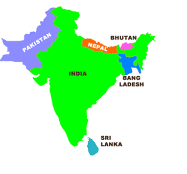
The Indian subcontinent is a peninsula that juts southward from the rest of Asia like an enormous arrowhead. The subcontinent is a self-contained landmass because it is separated from the rest of Asia by the enormous Himalayan Mountains. While it is a distinct landmass, the Indian subcontinent is not large enough to be considered a continent. Our study of the Indian subcontinent will also include the mountainous nations of Pakistan, Nepal, Bhutan, and Bangladesh. The region also includes Sri Lanka, an island nation off the southern coast of India.
The Indian subcontinent is part of a tectonic plate that has been moving for more than 200 million years. The plate was once attached to Africa, Australia and Antarctica. It separated and collided with Asia 50 million years ago. The land rippled up as the two landmasses met. That rippling is ongoing and is expected to continue for the next several million years. The land that was pushed skyward became the Himalayas, the world’s highest mountain range.
The colossal Himalayan Mountains include the world’s tallest mountains, many towering more than five miles above sea level. Himalaya means “home of snow” because the tallest peaks of the Himalayas are always capped with snow.
The Himalayas include Mount Everest, the tallest mountain in the world. Everest rises 29,028 feet above sea level on the border between India and Nepal. No plant life grows near the mountain’s peak due to powerful winds, extremely cold temperatures, and a lack of oxygen. Many adventurous people attempt to climb Everest every year. Often their venture ends in sickness or death. Most people are unable to breathe 20,000 feet above sea level because there is not enough oxygen in the atmosphere. A person will suffer brain damage when they are unable to breathe. Strong winds and frigid temperatures make the climate even more rigorous. Clearly the peak of Mount Everest is a place for only the heartiest of people.
Monsoons
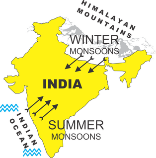
India’s climate is dominated by monsoons. Monsoons are strong, often violent winds that change direction with the season. Monsoon winds blow from cold to warm regions because cold air takes up more space than warm air. This means that monsoon winds blow from the land toward the sea in winter and from the sea toward land in the summer.
India’s winters are hot and dry. The monsoon winds blow from the northeast and carry little moisture. India’s winters are hot because the Himalayas form a barrier that prevents cold air from passing onto the subcontinent. Additionally, most of India lies between the Tropic of Cancer and the equator, so the sun’s rays shine directly on the land. The temperature can reach as high as 110oF during the Indian winter.
The summer monsoons roar onto the subcontinent from the southwest. The winds carry moisture from the Indian Ocean and bring heavy rains from June to September. The torrential rainstorms often cause violent landslides. Entire villages have been swept away during monsoon rains. Despite the potential for destruction, the summer monsoons are welcomed in India. Farmers depend on the rain to irrigate their land. Irrigated land has enough water to grow crops. Additionally, a great deal of India’s electricity is generated by water power provided by the monsoon rains.
Pakistan is much drier than India. The summer monsoon winds in India bring moisture from the Indian Ocean in the west, but Pakistan is north of the ocean, so it receives much less rain. The Thar Desert is on the border between India and Pakistan. Desert land receives very little precipitation. The Thar Desert covers more than 77,000 square miles, about the size of Nebraska.
